Trips Logo
Blog – Northwest Passage Blog

Blog

Day Sixteen - Safe Passage

And so it all came to an end. No sooner had it begun than it was all over. Time is not a constant. It is at its slowest during double Latin on a wet Monday afternoon and at lightspeed during trips of this nature.

We travelled over 2000 miles. And saw things that few humans have ever witnessed. Consensus was that our abiding collective memory would be navigating through the ice in Peel Sound. Those tense 48 hours where it could all have gone so badly wrong.

Polar bears, narwhals, belugas, walrus, and wolves all added colour to the canvas.

The final day reminded us that winter was on its way. Snowflakes drifted around our heads as we ran around the point, by the side of the Jakobshavn glacier, one last time. The Inuit taxi driver this morning, looking up at the snow sprinkled hills, said ‘winter is coming’.

Sherpa was made for the trip. The crew excelled. Julia is the luckiest child on the planet.

A family of fin whales swam around the boat in the evening as the sun set on our remarkable trip and we toasted our safe return in front of the log fire.

Bye. Jim

Day Fifteen – Icebergs

The day assumed a leisurely pace until around 3pm in the afternoon when we first sighted Greenland dead ahead. We then started to pass one colossal iceberg after another on a quite different scale to anything we had seen on the NW Passage.

We moored up in front of a delightful town called Ilulissat. Not at all what we were expecting after the scruffiness and neglect of Cambridge Bay and Resolute. The people here obviously take a real pride in their surroundings. It is a cheerful, colourful hamlet nestling around a natural harbour with an enormous glacier running alongside.

We went running. Always the best way to explore a new place. And experienced some of the most stunning views I have ever witnessed. Not because of the village and pretty fishing harbour but because it sits next to the northern hemispheres most productive glacier. The Jakobshavn Glacier. It is simply indescribably immense. It produces more icebergs per year than the whole of the USA uses in drinking water. If you get my drift. 46 cubic kilometres if you happen to be interested.

So we all here can claim a good number of firsts today….first time to see icebergs anywhere near this size, first time to see such an immense glacier, first time to see 5000 sled dogs scattered across the rocky plain next to the town, first time to eat on land for two weeks, first time to see the Northern lights so bright, first time to eat whale at the local restaurant, first time to eat musk ox at the local restaurant, first time in Greenland, first run in Greenland and on and on. Oh and there were a few whales, a first for one or two.

It’s all a bit too much!

Oh and not to forget. The Northern lights. A first for most.

Day Fourteen – Wild Seas

It was a wild night with an intimidating ugly sea that sat at no more than zero degrees. Enormous menacing waves up to 9 metres in height crashed continuously against the boat all night and gale force winds of 40 knots lashed it yet more. There was one moment in the depths of the night, when I had to grab the bedside table to prevent being thrown out of the bed. Not a stick of furniture remained upright on the boat.

Today it has moderated. Wind 30knots. Wave heights 4 metres. The ride is now comfortable with a following sea.

The beach club has become completely unusable. The waves are travelling faster than Sherpa, overtaking the boat from the stern and swamping the beach club. It is locked off for safety reasons.

We are half way across Baffin Bay.

Greenland tomorrow

Day Thirteen – Of Unicorns and Storms

We awoke in a wonderful fjord off the west coast of Baffin Island. Again we were blessed. The weather was perfect. And the water glass still.

We didn’t need to stray far. Just off the back of Sherpa was a polar bear and two cubs. We gently approached them in the Safe boat as they walked to the shoreline. We eased up to within 30 metres of them. It doesn’t get much better than this. We had an hour with ‘the three bears’!

Given Sherpa was merely 300m away we dropped in for a quick coffee and toast after.

And then set off again down a fjord called Icy Arm. The scenery was simply breath-taking. I don’t believe any of us has seen mountain scenery of its equal. Plunging cliffs, glaciers threading their way down to the water, hanging glaciers, huge moraines. And icy turquoise mirror water. It was scarcely believable.

And then those most elusive of creatures popped up. The unicorn of the sea. The narwhal. To top things off.

We are now bound eastwards to Greenland in storm conditions. A big sea and 30 plus knots of wind. Dinner was impossible. No glass would remain intact on any table on Sherpa. It’s rock and roll. Big time. Julia was having a ball dancing around but not all the adults!

It is now pitch black, with a howling wind, a following sea crashing into the beach club and the boat rocking crazily from side to side.

Time to turn out the lights and pray for morning.

Day Twelve – Enchanting

Sherpa has just entered a magical fjord on Baffin Island at eight o’clock in the evening after a long Passage. Full sun. A large glacier at the end. Towering cliffs on all sides. Huge moraines of ground up rock and gravel. It is quite enchanting. Totally remote. A land for polar bears.

We have had 24 hours at sea. And it has whistled by but not sure why. Spinning, chores, girls taking a cookery class, gym, and more. I have had no time to pick up a book.

I always remember someone saying the difference between Chamonix and Courchevel was that Chamonix was vertical whilst Courchevel was horizontal.

This place is vertical. In all directions. Dramatic. El Capitaine in all directions.

More tomorrow.

Day Eleven – Walrus and Bear

We awoke in Croker Bay on the south side of Devon Island, if you recall the worlds largest uninhabited Island over twice the size of Wales. It has an immense ice cap. Which should it melt would increase global sea level by one centimetre.

Two fingers from the ice cap crawl into Croker Bay. They are both colossal.

The morning is stunning. Not a breath of air. Bright blue cold skies. The surface water is freezing around Sherpa. A thin layer of crackled ice.

We take a run out in the Safe boat to see the glacier slide into the bay. It is kilometres wide. Maybe 30 metres high. Ice white and ice blue. The water was mirror flat. It took your breath away.

The thin layer of ice on the water surface offered little resistance to the eight tonne Safe boat but it was fun crackling our way through at 30 knots.

We headed back to Sherpa for coffee. And bumped into two walruses. As you do. Lying on an ice floe. Not a care in the world. And we moseyed up to within a few feet before they jostled their way back into the still icy water.

We also opted for a run before breakfast. Two separate groups each with a gun. We had run for 30 minutes when we heard the radio burst into life. Group two (the slower group with Julia) had spotted a large male polar bear headed in their direction. There was a frisson of anxiety before we realised the bear was a way off. That said it was a small reminder that we are alone in a very remote wilderness. Group two got smartly into the awaiting boat.

And we then had a simply glorious run across tundra and along deserted beaches stopping to look at polar bear and musk ox tracks. Special.

Another unforgettable day. And now steaming through the night and all of tomorrow for Baffin Island before the hop to Greenland. And a bit of weather predicted in the night.

Day Ten – Stripped for Action

The bar is cosy in the evening. The log burning stove radiates heat and we cluster around like bugs around a candle in Africa. Serena is writing her diary. Ben and Nick occupy the press seats sorting through the photos of the day. Charles is looking wistful. And Fi is responding to her many admirers on her iPhone. I either compose the blog or read the daily news. Julia comes and goes as if she was born on the boat.

It is a quite stunning evening. The sun is golden and turning the mirrored water to gold.

We have just watched a mother polar bear and two cubs on the shore as Sherpa gently wafted past. They retreated up a small canyon just off the shore.

That makes it 8 polar bears for the day. And as that was our mission for the day I think we can settle in the bar with a satisfied warmth.

There was a moment in the day when the word warmth was far from our thoughts. At the end of a stunning run this morning we stripped off shirts and plunged into the fjord. Zero degrees. Life expectancy 2 minutes max!!! An interesting experience…

….but maybe we have been at sea too long?

Day Nine – Desolation

We are anchored at Beechey Island. Franklin wintered here in 1845. Three men died. Their graves remain. Undisturbed by nature. One fellow was 22 years old. A grim reminder of how desolate and unforgiving this place is. Not a scrap of vegetation. Not a vestige of shelter. Icy waters. A cold northerly wind. Grey sombre clouds. God only knows what winter in darkness felt like.

The morning. Belugas. Lots of them. A wonderful liberating run along the shoreline for two hours.

In the afternoon we paid homage to Franklin’s lost souls.

A thoughtful and introspective day.

….with a twist at the end. We were cruising along the southern coast of Devon Island at 8pm this evening in Sherpa. We spotted a creature on the shore a mile away. We launched the Safe boat in our evening dress (!). It was a lone white wolf. We came within 50m. Unforgettable evening.

Day Eight – A Near Miss

We awoke in Resolute. Or in the bay at least. Resolute as in the presidents desk. This time last year apparently it was completely icebound. Today is glorious sunshine with a high of 2 degrees.

It is tiny. Less than 200 folk. But all friendly. And scruffy. Like a ski resort it probably looks better with a clean white carpet laid down with the rubbish swept underneath.

We went for a 10km jog. As you do. Everyone waved. And I mean everyone. I doubt they had witnessed this before.

We set off for the tiny airstrip 5km away. 7 of us plus Doug bearing arms. Except Doug has got some gastric thing and was unable to maintain my blistering pace 😊.

As we approached the strip we were flagged down by an army guy in fatigues in a giant pickup. “Polar bears mate. Around the corner. Hungry. Where’s your backup?” “Erm, actually about 4km back”. “Mmm you’re not from these parts are you?”

We turned around sheepishly and headed back into town. But seriously a warning to us all. These big white guys (and I’m not talking about the army) are ferocious and not to be messed with.

We won’t make this mistake again.

We had a coffee in town at the hotel. Yes they have a hotel. Again charming people. They wouldn’t allow us to pay. Mind you the coffee was shit.

After lunch we went for a boat ride looking for those polar bears but of course found none. We did see a very large and curious bearded seal.

And then sundowners on the rocks on a glorious summers evening.

Day Seven – Part 1

Berg 

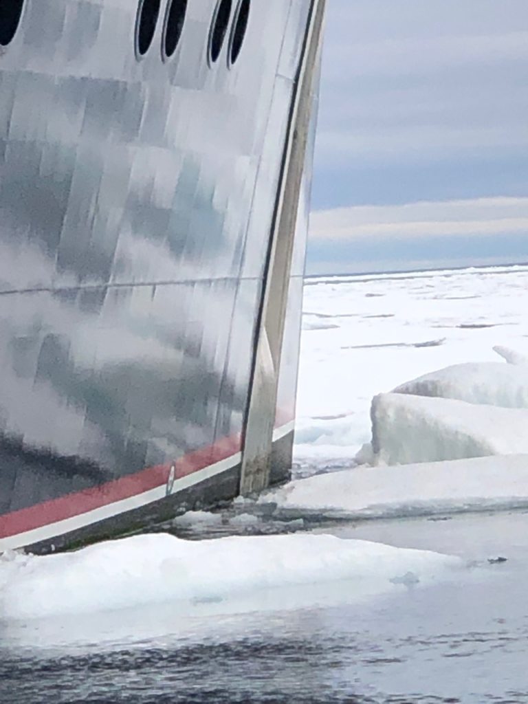
Our overnight passage took 8 hours instead of 4 due to manoeuvrings around ice. But we made it safely. And there was some serious rock and rolling as we went beam on to the swell for awhile. In my case it aided sleep. But not in all!

We identified an intriguing looking bay (Digby) on the chart this morning just east of where we are anchored in Radstock Bay. There is a river coming down into the bay and I am excited about these huge polar Arctic char that run to salmon size.

It turned out to be a great drive for an hour in the Safe boat with seabirds and impressive scenery. Whilst our hopes were up the fish were not. Up the river that is. Hey but we walked alongside huge polar bear tracks. And I mean big.

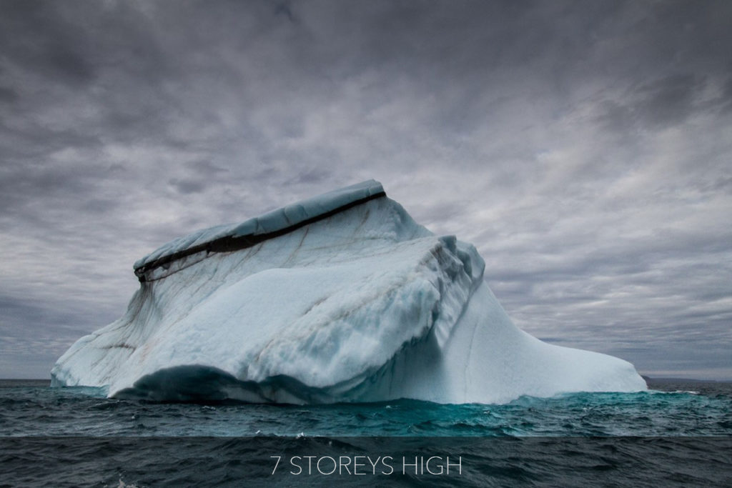
The sighting of great note was the iceberg. Above water it was the size of Hans Crescent. The real deal. No one had seen its likes before.

Day Seven – Part 2

Alive

No sooner had we returned to the boat, had a few cheese toasties, than we were back in our boots. This time to climb the local peak. Caswall Tower. Look it up, it is impressive. It was steep. Uncomfortably steep. But as they say if you don’t feel uncomfortable from time to time you are not alive. It does feel good when you have mastered your fears. Although not necessarily whilst you are doing so!! Doubtless there will be a few photos on the blog but we wouldn’t wish to tackle anything more ambitious than this ascent. That said there was a hut at the summit. Seemingly 20 years ago a researcher had lived up there observing polar bears presumably with a telescope. Any normal society would have condemned him to an asylum but Canada is more lenient. We had a sundowner on the summit. I guarantee no one has ever…ever…downed a gin and tonic on top of this mountain before!

Julia leaves tomorrow for school. This place is so so much more educational. And we have yet to find the narwhals….or a true close up of a polar bear.

Fact of the day. We are in Devon Island here. What is the trivial pursuits question? It is the largest uninhabited island in the world.

Bye. Jim

Day Six – Part 1

No Ice in Sight

We are through. The coastguard has just officially closed Peel Sound this morning. No one will follow Sherpa. The NW Passage is closed for 2019. We are not aware of any other boat that got through from the Pacific other than Sherpa. The window for transit was literally 36 hours. If you look at the map, ice flows into Peel Sound at the bottom from McClintock Channel that is permanently ice bound, and at the top from Parry Channel in the west which again is full of ice. When a big North Westerly blows (as it did yesterday) it simply shuts in Peel Sound from both ends. We miraculously sneaked through in the tiniest of windows. Last night was touch and go until 4am. At midnight Jako anchored up as we were getting lost in a maze of ice passages, the fog came down and we risked getting ourselves wedged in with ice moving in the strong winds. At 1.30am we had a broad sheet of ice moving in towards us and threatening the boat. Jako chose to lift the anchor and return back West to look for an opening. This did not materialise. He turned around to look East. Miraculously a lead opened up at 3am and we steamed through. By 4am we had successfully made it through the NW Passage. We are now anchored just around the point from Prince Leopold Island. It is a bleak and unforgiving landscape. We are off to look for polar bears and beluga whales. More later. Oh and a short potted history to follow. Puts things in perspective. God knows how they coped 300 years ago.

Day Six – Part 2

Franklin

The mystique of the NorthWest Passage revolves around the Franklin expedition that ended in tragedy in 1847 with the loss of all men and remained an unsolved mystery for many years.

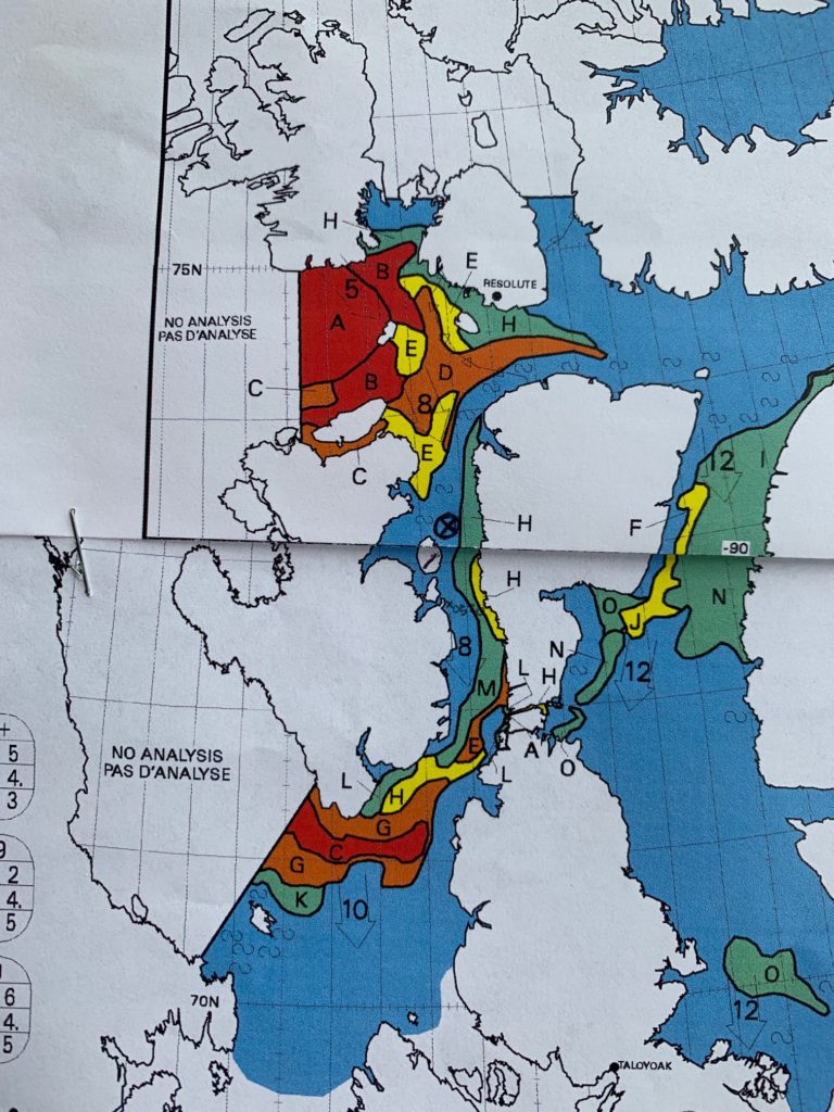
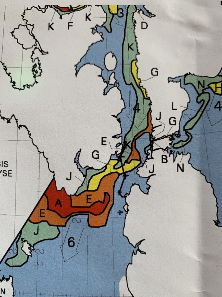
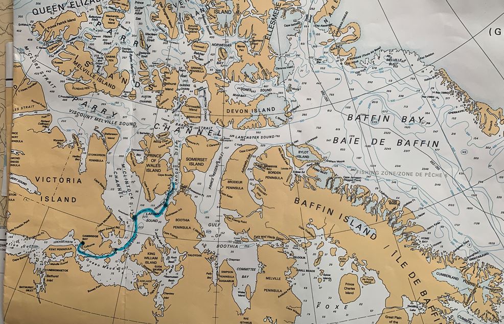
To understand the notes below it will be useful to view this simple map occasionally.

History

First a little gentle history to set the scene. Martin Frobisher of the Royal Navy first had a crack at finding a way through to the Pacific in 1576. In all he led three expeditions.

Henry Hudson followed in 1610. And we all know what he found.

And in 1612 William Baffin found and mapped his island.

Much went on in the next 200 years but we were distracted by trading furs and making money in Hudson Bay and the famous Hudson Bay Company.

Things rebooted again with Edward Parry in 1819. He importantly pioneered the Parry Channel which is the main conduit West above Baffin Island.

In 1829 James Clarke Ross found the magnetic North Pole on Boothia Peninsula. He was sponsored by the gin tycoon Felix Booth. But importantly (see map) he didn’t go down Peel Sound but Prince Regents Inlet and then trekked across.

So now back to Franklin.

Franklin Expedition

Franklin made his first expedition in 1818 when it was thought that there was an open polar sea beyond the ring of ice. Being fabled it was not found!

In 1819 he returned back to the Arctic. This time to lead an overland expedition from Hudson Bay up the Coppermine River which comes out not so far from Cambridge Bay. Effectively the Pacific end of the NW Passage.

He lost 11 of his 20 men but only one Englishman. As a consequence he was hailed a hero in Victorian England.

He was awarded the Governorship of Tasmania which kept him busy for awhile but didn’t go well.

He couldn’t resist a third attempt at finding the NW Passage doubtless partly fuelled by his need to restore his reputation. He captained an Admiralty sponsored expedition in 1845 with two ships the Erebus and the Terror and 129 men.

He went missing.

Rescue

In the next 10 years 36 expeditions set off to rescue or find what happened to Franklin and his men.

In 1854 John Rae engaged with the Inuit living near King William Island. They talked about a group of 40 white men on King William Island. And they had some relics from the Franklin expedition. Rae returned home to the UK.

Three years later, the Admiralty having failed three times, Franklin’s wife Jane sent a small rescue team under a skipper called McClintock with 25 men in a modest but nimble boat. He discovered a letter under a cairn on the northern tip of King William Island saying that the men were headed on foot for the mainland of North America across from King William Island. He also found some bodies.

In 2014 Erebus was discovered just south of King William Island. In 2016 the Terror was found on the south west corner of King William Island.

So now we know.

Franklin did in fact find Peel Sound. He sailed through it. He was the first to do so. Peel Sound is the key to the maze. It links the Eastern attempts with the Western attempts. It is the only way through. McClintock Channel is always choked with ice. Prince Regent Inlet is a dead end. Peel Sound is dead centre and open. Well open sporadically and always partially ice bound. But it is the only navigable way through. And it is where we are right now.

Amundsen

We move rapidly on to 1903. Roald Amundsen of South Pole fame became the first man to successfully sail the NW Passage. In a small boat of 70 feet, only 6 crew and a 13hp engine as well as sail he found Peel Sound and then King William Island as had Franklin. He went the other way round King William Island (ie not through Victoria Strait) having read John Raes notes about open water on that side. He took 3 years. Interestingly he spent 18 months with the Inuit on King William Island learning their arctic skills. These he used to great effect in the race with Scott to the South Pole.

It is arguable that Franklin was the first man to navigate the NW Passage, at least the core of it, but he perished in doing so. Amundsen sailed the whole thing and emerged successfully into the Pacific.

The Presidents Desk

One of the Admiralty rescue missions for Franklin was lead by Belcher. He had a fleet of 5 ships. One was called Resolute. It became trapped in ice where the town of Resolute is now located. It was abandoned in 1854. A year later astonishingly it was found eerily bobbing around in the Baffin Sea by an American whaling ship, having freed itself from the ice.

It was towed to the USA. Restored by the US government. And presented to Queen Victoria as a gift.

It served a further 20 years before being scrapped. When it was scrapped Queen Victoria requisitioned some of the wood from the Resolute and fashioned it into an ornate desk which she presented back to the US president, Rutherford Hayes, as a gift.

Today Donald Trump sits behind it in the Oval office.

Day Six – Part 3

It’s Back

It’s 21.34 on Saturday evening. Again we have abandoned dinner as we have hit more ice that has been blown down Parry Channel. We are heading across to the northern side of Parry which is ice free. We didn’t want to risk more ice drifting down in these strong winds and blocking us in.

We have just broken our way through some big multi year pieces of ice. The string was maybe 250m thick with a swell running. We managed our way through but not without a couple of big collisions which shook Sherpa to its keel.

We have a further 3 hours steaming north and we can see another line of ice on the horizon. We are taking an easterly route in an attempt to circumnavigate. We don’t want more encounters with this heavy ice.

But back to today. We sheltered in a bay on the north eastern corner of Somerset Island called Leopold Bay. We had company. A school of beluga whales cavorting around without a care in the world. Maybe 1000 of them in a giant pod. A special sight. And then after lunch a jog/hike along the beach and a small plateau. Over streams, through snow banks and stopping periodically to look at remains of old settlements and whale bones. It really is a grim bleak place. Unthinkable to winter here as Ross had done in the early 1800s.

Ice line approaching.

More tomorrow.

Day Five – Part 1

​A Turn for the Worse

It is Thursday morning 10am. We are driving through a north-westerly gale almost on the nose, gusting 40knots (75 kph). Sea state lively. Scattered ice the size of locomotives. Difficult to see in the whitetops. Some fog. Flurries of snow. Windchill minus 15. Intolerable on deck for more than 10 minutes.

Ice breaking away from the top of Peel Sound and coming down the straits. We are trying to reach the top of Peel Sound before this northwesterly blows the ice pack across the mouth of the sound and blocks us in.

A white line of ice on the horizon ahead of us. Density unsure. Not indicated on ice chart.

If you look at the map below you can see the extensive ice pack west of the top of Peel Sound. This is being blown across to the right compressing the remaining gap through on the easterly corner (see orange D which is impassable multiyear ice except for icebreakers). Sherpa is marked by a cross. Blue water is clear of ice…in theory, in practice not at all.

Day Five – Part 2

Settling

It is 19.00 hours. The wind backed off to 30 knots in the afternoon and the ice remained scattered. We have a pinch point at 2am this morning where the ice may have impinged the free channel. But at the moment all looks good. We are emerging from Peel Sound and bearing East. There is a tail of ice to our left which stretches another 30 miles.

We are confident enough to be retiring to the bar now!!

Day Five – Part 3

A Wall of Ice

It is 8.48 in the evening. We have abandoned dinner. We are confronted by a wall of ice that stretches fully across our path. It is maybe 150m at its narrowest point. It is extremely compacted. Big chunks of ice have buckled with the pressure and pushed metres into the air. We have no idea whether Sherpa can penetrate this type of ice. It is thick multiyear ice. We are standing off about 300m while we consider options. But frankly there aren’t many.

This is not 8/10 ice. This is 10/10ths. And again doesn’t exist on the ice chart. It has been blown in by the gales.

We have eased close to the ice barrier. We can now assess the ice conditions more exactly. The ice pilot has advised against any attempt to break through this old compressed ice. Too dangerous. He said that even an icebreaker would find this tough going. We are going to scout for a more open situation.

It is going dark.

Day Four – Part 1

Closing In

We are heading up the centre of Franklin Strait. It is 8 am. We are approaching the band of ice that cuts us off from continuing north into Peel Sound. From here, a mile off, it looks like solid ice with no possible way through. The ice chart says 4-6/10ths ice. The top end of this range is beyond our capability. Our IcePilot is on the radio loudspeaker talking to the captain of Canadian Icebreaker Resolute that we can just about see 12miles ahead.

He is telling us that he is in open water 12 miles north implying that the solid ice pack is around 10 miles thick.

We have ice on the mast and on the deck. We had horizontal snow when we picked up the anchor this morning.

We will drop the safe boat in the next 15 minutes and then try to weave our way through the ice maze ahead of Sherpa.

We have been advised that we need to steam straight through Peel Sound as it is closing in at Resolute at the north end of Peel Sound and ice is blowing in from McClintock Channel in the south. Getting trapped here between these two ice packs is not a desirable scenario.

If you recall Sherpa sailed from Dutch Harbour in the Aleutians around to Cambridge Bay where we met her. This passage is no longer navigable as ice has blown in and blocked the route. So there is currently no retreat West.

Map below. We are between G and J about to attempt to get through the yellow band. Yellow is 4-6/10ths ice cover on the sea surface.

More later.

Day Four – Part 2

Pack Ice

10.16am. I am sat at the wheel of the Safe boat 50m astern of Sherpa. All the guests are on board the Safe boat. I have just been served a steaming mug of coffee. Ben the photographer has just climbed on the roof.

We are surrounded by ice. Coverage I would guess is 80%. Sherpa is driving her way through and the ice is yielding. We are following in the open lead that she is creating. The Safe boat weighs in at 8 tonne. It wouldn’t have a cat in hells chance of getting through. Some of the ice is over a metre thick and the plates are the size of half a tennis court.

Whilst just writing then we had a sticky moment. We drifted off the pace and the ice was closing in around us. I have no idea how we would have extricated it if we hadn’t nipped through a briskly closing gap!

So far we are a mile into solid ice. We can see an open lead ahead.

Julia is steering whilst I am writing.

We have reached an open area now where we can settle for 10 minutes. We have climbed back aboard Sherpa. Shortly we will continue on through the pack ice.

Day Four – Part 3

Ice Squealing

14.30. The whole boat shudders. And grinds to a halt. It has hit another piece of multi year ice. Some are much larger here than tennis courts. They weigh hundreds of tonnes. Sherpa either grinds by, bounces off or cracks it’s way through. The ice shrieks and squeals as it resists Sherpa.

The ice stretches endlessly in all directions. It has thickened up here but we are in sight of an open lead between us and the coast 6 miles away. We have been through a lighter patch in the middle but this is tough going.

A long way to go.

Day Four – Part 4

Breakthrough

Daylight finally so to speak as dusk approached. We emerged into open water in Peel Sound at 8pm this evening.

We are presently steaming under full engines.

It is now a race to beat the ice at the top of Peel Sound which is cutting us off at a rate of 8 miles per day.

And a big storm is brewing.

Day Three – Larsen Sound

We have finally struck ice. Out of the blue. So to speak.

We travelled all night but we awoke this morning to clear waters as we have become accustomed to over the last few days. An hour later we could see on the horizon a white line that stretched endlessly in both directions.

Twenty minutes later we arrived at solid ice. There were no transition fields of broken scattered ice. Just a line of 100% ice stretching as far as the eyes could see both left and right. The mouth of McClintock Channel stood fully before us choked with ice. 60km wide. There would be no passage through here.

We dropped the Safe boat and drove over to touch the ice (for prosperities sake as they say). We were almost emotional at this moment but fortunately managed to control ourselves . The ice was an intense blue turquoise. Broken up but compact. The sea state was lively in a 25 knot breeze and the sizeable waves crashed onto the icy ledge.

No sooner had we touched the ice than the radio burst into life. Jaku on the bridge had spotted a polar bear. Well that didn’t take long. A cream speck about a kilometre away. And hour later we saw a further three.

It is cold here. The water is zero degrees. Life expectancy around one minute. The waves are intimidating. The wind goes straight through you. It is as inhospitable a place as one could imagine. I take my hat off to the Inuit. Astonishing that they can survive. And it has not escaped me that this is mid summer. How soft a life we do lead today.

In the afternoon Sherpa traversed across Larsen Sound to the small group of Tasmania islands on the eastern side. We are actually now in Franklin Straits. We took a two hour hike over one of the islands to be met by the boat and a rather unique sundowner setup on the far side. In all likelihood no man has ever stepped on this island and certainly not downed a gin and tonic or WhiskyMac. It was barren. Lifeless. Scoured. Hostile. No vegetation. No shelter. But with strange rocks and lichen and the odd shell.

Sadly no gold.

The weather prognosis is not good. Violent winds are due in the next couple of days from the north which will push ice into Peel Sound making it unnavigable for Sherpa. So we really need to push through in the next days. The snag lies in the ice chart which is presently indicating a thick string of ice across the middle of Peel Sound. We will have to go take a look and see if we can wriggle through before we get beset by bad weather.

It is going to be quite a day tomorrow I suspect.

Day Two – Gateshead

A travelling day, and night. Whilst we all feel comfortable on the move there is always a hint of tension when underway especially at night. This place hasn’t been charted in any regular sense. No boats have made it up here to do the charting!

We took the Safe Boat out this morning to explore a remote island where we had moored up for breakfast. We scraped a reef 500m offshore. No warning. Nothing on the chart. And we never did find a place to land as the shallows were simply too shallow to approach land. A warning to us all.

So an hours spin instead of a hike, breakfast and back underway.

We are heading for Gateshead Island where we will anchor up over night. We will be on the ice boundary. There the adventure will begin.

We need to get through Peel Sound or across into Prince Regent Inlet in the next few days in order to reach the Parry Channel or Lancaster Sound. But currently they are both blocked with ice. This section of the journey is notorious and the majority of boats simply do not get through. We get daily charts with updated ice formations that change dramatically with wind and current. We remain hopeful of a breakthrough

Check out the new map. We will update every day.

I am jet lagged. More tomorrow!

Day One – Cambridge Bay

This small hamlet on Victoria Island sports 1800 residents half of which are Inuit. It is scruffy. Littered with pick ups, quads and snowmobiles. It is the largest stopping place on the NW Passage. It sits 300km north of the arctic circle. But there is strangely no ice to be seen. The island of Victoria is interesting. It is the worlds eighth largest island and almost twice the size of England. Cambridge Bay is its largest town.

We took a 4 hour bike-hike this morning to the summit of the local mountain. 40km. Julia drove a quad. Stupendous views of endless desolation in all directions. Beautiful in a haunting sort of way.

Eskimos have survived here for 4000 years hunting seal and caribou. We wouldn’t last a week.

Sherpa looks the part sat in the bay. There is one other yacht here. The sailors aboard attempted the NW passage last year (one of only three) but got caught in the ice and the yacht was crushed and sank. With the monies from the insurance payout they bought another boat and are here again. But….a few weeks ago they hit an iceberg and tore a hole in the bow. Shit happens up here.

The rest of the guys arrive in an hour of so.